

Last week I went out on my first solo walk of the year. A bit of rambling above Rothbury. Solo walking is a unique experience, very different to walking in groups. There is no timetable and no fixed route. It is the very definition of freedom and I enjoy it very much.
Recently, I’ve been walking with groups but not alone. I’ve also been a bit busy and considering the recent storms, I haven’t missed being out too much. But the storms have abated and the weather improved. So, last week the weather was particularly good. The blue skies and mild temperature, for March anyway, were tempting me out. Eventually, I gave in.
I decided to go to Rothbury and take a route that I needed to check out for Strolls With Poles. I know Rothbury very well and have walked here a great deal. However, for a few years, I’ve been investigating the rest of Northumberland and have neglected the area around Rothbury and the Coquet Valley. An area which once enchanted me during my initial experiences of walking in Northumberland. I was quickly reminded of how beautiful this area is.
Setting off
It wasn’t a particularly warm day but as I got closer to Rothbury the temperature kept dropping. I noticed that the car thermometer was indicating 1°C, as I pulled into the car park at Cowhaugh. There was still frost on the grass. I prepared and dressed for a cold days walking.


Setting off, I went across the little pedestrian bridge, across the Coquet, and into Rothbury centre. I crossed the road and set off up the narrow nick by The Narrow Nick pub. This path leads up through Hillside via narrow lanes, eventually emerging at Blaeberry Hill.
I found my thrill on Blaeberry Hill
Thrilled that I actually got to here without collapsing that is. I’m not as fit as I thought I was and the route up to here is steep. I decided to take a breather and admired the view for a while.
This hill is plainly named after the Blaeberries or Bilberries that grow in this area. Not really here anymore though, as this area is given over to high-end residences, that have the luxury of an amazing view.
Come alive up on Carriageway Drive
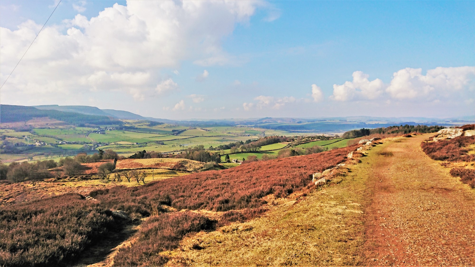
At the top of Blaeberry Hill, there is a path that leads onto the moorland above Rothbury. I took this and, on emerging onto the moor, took a path to the left. This led up towards Ship Crag, where the first of the amazing views can be seen. On reaching it, I found another couple sitting there enjoying the view. I wished them Good Morning and carried on.

The sky was blue and there wasn’t any breeze at all. It even felt warm, even though the puddles were frozen over. What a great day. It was wonderful.
I’d forgotten how incredible this area is. Forgotten how much I enjoyed it. But I was here now and remembering how it was. The heather, even at this time of year looked fantastic and, despite a haze in the air, the views were spectacular. The outline of Simonside was clear and, in the distance, the Cheviots Hills were visible. Cheviot and Hedgehope are unmistakable. The Coquet river wound its way up the valley, towards its source in the Cheviots at Chew Green.

Walking round the Western end of the Carriageway opens up an even wider vista to the most Northern extent of the Cheviots. Much closer is the remote but beautifully named homestead Glitteringstones.
Trench foot
I had decided that this time I would make an effort to find the WWI practice trenches. This area was used to train troops in trench digging before being sent to the battlefield. I’d always though they were hidden but once I was looking for them I realised that they were in plain sight and, what’s more, right next to the path. Maybe I’d put them down to land management before but once you see them they are everywhere.


I walked a few of the trenches. They’ve obviously filled in a bit and the walls are undoubtedly less straight than they originally were but the zig-zag pattern is clear. A very interesting diversion from the walk and definitely worth a look.
Walking in the woods
Continuing on moorland changes into woodland. The songs of woodland birds replace the sounds of hawks overhead (that’s the RAF Hawk trainer not the birds) and geese flying North. They looked like Marsh Tits or Willow Tits but it was difficult to tell. They move fast and by the time I’d raised my binoculars and aimed them they had moved. Apparently, the way to tell the difference is by their call but, as I didn’t have my trusty bird spotters guide, I didn’t know which calls were which.

I came to a gate onto an old track. This track heads down to Primrose Cottage, through some woods. It used to be a lodge on the Cragside Estate but is now a private residence. I wasn’t up for the shortcut and followed the original route of the Carriageway Drive. This still arrives a Primrose Cottage but via the outskirts of the Woods. The path is above a small river valley where the Debden Burn runs. As a result the views are far better, with Debden Farm visible near the source of the burn.

From Primrose Cottage I went North a little and then followed a path through some woods to a stile. This led out onto open moorland and wet open moorland too. There went my hopes of my feet staying dry for the day. Never mind, it’s a hazard of walking outdoors. This path ran directly South and eventually to the place I’d first arrived on the moor. No sense in going back the way I came though, especially when one of the best parts was yet to come.
Addycombe back
Addycombe is clearly manufactured to look pretty and it is very effective. It has attracted local people for some time. The graffiti on the rocks at the favourite viewpoint illustrates this. Much of the graffiti dates to the early 20th century.

I followed the old Carriageway Drive through the woods. I love this part of the walk. It’s like a small part of the Cragside woods but you don’t have to pay to get in. I usually start any walk up here by climbing through these woods. This route is the other way round, so I assumed that I’d end up in the same place, but I didn’t. The path came out on a bridleway that is part of a route to Addycombe Farm. A private gate blocks the bridleway here. However, there is a path that heads back down to Hillside Road.

From Hillside Road, it’s simply following the diagonal path that crosses some strip fields and then back into Rothbury. My final task was a quick trip to the butchers for a lunchtime pie. Then back to the car and off home.
Another lovely, rewarding and constructive day of walking in the outdoors.


